
Object Record
Images
Metadata
Catalog Number |
2007.500.015 |
Object Name |
Map |
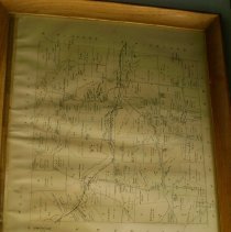
Description |
Map of West Pikeland. |
Date |
09/26/2008 |
Creator |
Unknown |
Dimensions |
H-22.5 L-18.5 D-1.25 inches |
Collection |
HYS Collection |
Caption |
Map of West Pikeland |
Classification |
Maps |
Condition |
Excellent |
Credit line |
HYS Collection |
Depth (in) |
1.25 |
Dimension Details |
Includes frame. |
Dimension type |
1 |
Height (in) |
22.5 |
Length (in) |
18.5 |
Notes |
"We believe this to be an accurate map and it gives us great pleasure to affix our official endorsement...Joey Reynolds M C James W MacFeur - Counry Conneussiouers" From Breou's Atlas, Chester County |
People |
James, M. C. MacFeur, W Reynolds. |
Search Terms |
Maps Yellow Springs |
Lexicon sub-category |
Documentary Artifact |
Subjects |
Maps |
Title |
West Pikeland |
Year Range from |
1883 |
Year Range to |
1883 |